Houston Flood Zones Explained: FEMA Maps, Insurance Costs, and Which Areas to Watch
Houston Flood Zones Explained: FEMA Maps, Insurance Costs, and Which Areas to Watch
So if you're buying a home in Houston, flooding is going to come up in every conversation -- with your agent, your lender, your insurance company, and your family back home who watched Hurricane Harvey coverage on the news. And here's the deal: the question isn't whether Houston floods. Houston floods. The question is whether the specific property you're considering is at meaningful risk, how much flood insurance will cost, and what the city has done since 2017 to reduce that risk.
Most flood content falls into two camps: fear-mongering articles that treat all of Houston as an underwater disaster zone, or booster pieces that wave away flooding as "not that big a deal." Neither is useful when you need to make a decision about a specific house.
I treat flooding as a data problem. FEMA maps, insurance cost ranges, historical flood events, and infrastructure improvements -- all sourced, all verifiable, all designed to help you evaluate flood risk the same way you evaluate school ratings or property taxes.
How FEMA Flood Zones Work in Houston
Let me walk you through the basics. The Federal Emergency Management Agency (FEMA) classifies flood risk into zones that determine whether flood insurance is required and how much it costs. Houston spans parts of Harris County, Fort Bend County, Montgomery County, and several other jurisdictions, each with detailed flood maps maintained by FEMA and updated periodically.
Zone A (including AE, AH, AO) designates high-risk areas with a 1% annual chance of flooding -- commonly called the "100-year floodplain." In Zone A, flood insurance is mandatory for any federally backed mortgage. Zone AE is the most common designation in Houston and includes specific base flood elevation data that determines construction requirements and insurance premiums. Homes in Zone A along Houston's major bayous -- Buffalo Bayou, Brays Bayou, White Oak Bayou, and Cypress Creek -- carry the highest flood insurance costs and the most restrictive lending requirements. (Source: FEMA Flood Map Service Center, fema.gov/flood-maps)
Zone X (shaded, also called X500) designates moderate-risk areas with a 0.2% annual chance of flooding -- the "500-year floodplain." Zone X shaded areas don't require flood insurance for federally backed mortgages, but a lot of lenders will recommend it. And here's why that matters -- during Hurricane Harvey in 2017, a significant number of homes in Zone X experienced flooding because the storm exceeded the 500-year rainfall threshold in multiple Houston watersheds. (Source: FEMA Flood Map Service Center; Harris County Flood Control District post-Harvey analysis)
Zone X (unshaded) designates minimal-risk areas outside both the 100-year and 500-year floodplains. Flood insurance isn't required but remains available at preferred-risk rates. Properties in Zone X unshaded still account for roughly 20% of all NFIP flood claims nationally, because flooding can occur anywhere rain falls and drainage systems are overwhelmed. (Source: FEMA National Flood Insurance Program claims data)
How to Look Up Flood Zone Data for Any Houston Address
The good news is you can check this yourself in about thirty seconds. Buyers can verify FEMA flood zone designations for any Houston-area property using two free online tools. The FEMA Flood Map Service Center at msc.fema.gov allows you to search by address and view the current effective Flood Insurance Rate Map (FIRM) for that location. The Harris County Flood Control District maintains a separate interactive mapping tool at harriscountyfcd.org that overlays FEMA zones with Harris County-specific data including bayou locations, detention basins, and recent infrastructure project boundaries.
Both tools are free to use. The FEMA tool shows the official flood zone classification that determines insurance requirements. The Harris County Flood Control District tool provides additional context on drainage infrastructure and planned improvements that may affect future risk assessments.
For properties in Fort Bend County (including Sugar Land and Missouri City), the Fort Bend County Drainage District maintains a comparable mapping tool at fbcdd.org. Montgomery County (including The Woodlands) flood data is accessible through the San Jacinto River Authority at sjra.net.
If your agent hasn't checked these for you, you need to check them yourself.
What Flood Insurance Actually Costs in Houston
So what does flood insurance actually cost? This changed significantly in 2021 when FEMA rolled out something called Risk Rating 2.0. The National Flood Insurance Program (NFIP) transitioned to Risk Rating 2.0 in October 2021, fundamentally changing how flood insurance premiums are calculated in Houston. Under the previous system, premiums were based primarily on whether a property was inside or outside a mapped flood zone. Under Risk Rating 2.0, FEMA calculates premiums based on individual property characteristics including distance to the nearest water source, property elevation, replacement cost, and the specific flood frequency for that location.
Zone A (high-risk) annual premiums in the Houston metro area typically range from $1,500 to $4,000 or more for residential properties under Risk Rating 2.0. Properties with lower elevations relative to base flood elevation or closer proximity to bayous pay toward the higher end of this range. Homes that have been elevated above base flood elevation can see significant premium reductions. (Source: NFIP Risk Rating 2.0 rate tables; FEMA.gov)
Zone X (moderate and minimal risk) annual premiums for preferred-risk policies in Houston typically range from $400 to $800 per year. These policies cover up to $250,000 in structure damage and $100,000 in contents. For buyers in Zone X who want coverage despite not being required to carry it, this represents a relatively low-cost safeguard against storm events that exceed historical patterns -- as Hurricane Harvey demonstrated. (Source: NFIP preferred risk policy rate tables)
Private flood insurance has become increasingly competitive in the Houston market since 2018. Private insurers including Neptune, Wright, and Palomar offer policies that may be priced below NFIP rates for certain properties, particularly newer construction built to current elevation standards. Private policies may also offer higher coverage limits than NFIP's $250,000 cap, which matters for homes valued above that threshold. I always tell my clients to compare both NFIP and private options before purchasing. (Source: Texas Department of Insurance flood insurance guidance)
My honest take -- if you're buying in Houston, get flood insurance regardless of what zone you're in. Four hundred to eight hundred dollars a year is cheap peace of mind in a city that gets fifty inches of rain annually.
Houston's Major Flood Events: A Timeline
Houston's flood history is shaped by its geography -- flat coastal terrain, clay soils that resist absorption, and a network of bayous designed to channel stormwater to Galveston Bay. Let me walk you through the four major flood events in the past 25 years that have redefined how Houston approaches flood infrastructure and how buyers evaluate risk.
Tropical Storm Allison (June 2001) dropped over 35 inches of rain on parts of Houston in five days and caused an estimated $9 billion in damage. Allison devastated the Texas Medical Center, flooded thousands of homes along Brays Bayou and Buffalo Bayou, and exposed critical weaknesses in Houston's drainage infrastructure. The Medical Center alone suffered $2 billion in damage and subsequently invested $580 million in flood protection including submarine doors and elevated critical systems. (Source: NOAA National Weather Service; Texas Medical Center flood mitigation reports)
Tax Day Flood (April 2016) dropped over 17 inches of rain in 12 hours on parts of northwest Harris County. More than 7,000 homes flooded, primarily along Cypress Creek and the Addicks Reservoir watershed in the Memorial and Katy areas. The Tax Day Flood was significant because it affected neighborhoods that had never flooded before, demonstrating that flood risk in Houston extends beyond historically mapped zones. (Source: Harris County Flood Control District; NOAA storm data)
Hurricane Harvey (August 2017) was the defining flood event in Houston's modern history. Harvey dropped over 60 inches of rain on parts of southeastern Harris County over four days -- the highest recorded rainfall from a single storm in the continental United States. More than 150,000 homes flooded across the Houston metro area. The Army Corps of Engineers made controlled releases from the Addicks and Barker reservoirs in west Houston, flooding thousands of homes in the Katy and Memorial areas that had never experienced reservoir flooding. And here's the number that changes everything -- an estimated 80% of flood damage occurred outside mapped FEMA flood zones. Harvey caused an estimated $125 billion in total damage. (Source: NOAA; Harris County Flood Control District; U.S. Army Corps of Engineers after-action reports)
Tropical Storm Imelda (September 2019) dropped over 40 inches of rain on parts of northeast Harris County and Chambers County in two days. While less widespread than Harvey, Imelda flooded approximately 4,000 homes, primarily in the Kingwood, Huffman, and northeast Harris County areas. (Source: NOAA; Harris County Flood Control District)
What Houston Has Done Since Harvey: The $2.5 Billion Bond Program
Here's what happened next -- and this is the part that matters for buyers. Harris County voters approved a $2.5 billion bond in August 2018 -- the largest flood infrastructure bond in U.S. history at that time -- to fund more than 230 flood mitigation projects across the county. The Harris County Flood Control District (HCFCD) manages these projects, which include channel widening, new detention basins, property buyouts in the highest-risk areas, and bridge replacements that improve water flow.
Buffalo Bayou improvements include channel modifications and increased detention capacity along the bayou from Shepherd Drive to the Houston Ship Channel. These projects directly reduce flood risk for properties in the River Oaks, Memorial, and East End neighborhoods that sit within the Buffalo Bayou watershed. (Source: HCFCD bond program status reports, hcfcd.org/bond-program)
Brays Bayou improvements include the Project Brays channel widening and deepening project, which increases the bayou's capacity from its confluence with the Main Street bridge through the Medical Center and Meyerland neighborhoods to Highway 6 in the west. This project reduces the 100-year floodplain footprint for thousands of properties in the Meyerland, Westbury, and Bellaire areas. (Source: HCFCD Project Brays status updates)
Addicks and Barker Reservoir modifications remain under the jurisdiction of the U.S. Army Corps of Engineers rather than Harris County. As of 2026, the Corps has completed dam safety modifications at both reservoirs but hasn't significantly expanded reservoir capacity. The controlled releases during Harvey remain a concern for homeowners in the Katy and Memorial areas downstream of the reservoirs. (Source: U.S. Army Corps of Engineers Galveston District)
Is Houston flood-proof now? No. No city is flood-proof. But Houston has invested more money in flood infrastructure since Harvey than any metro in the country. And that matters when you're evaluating risk.
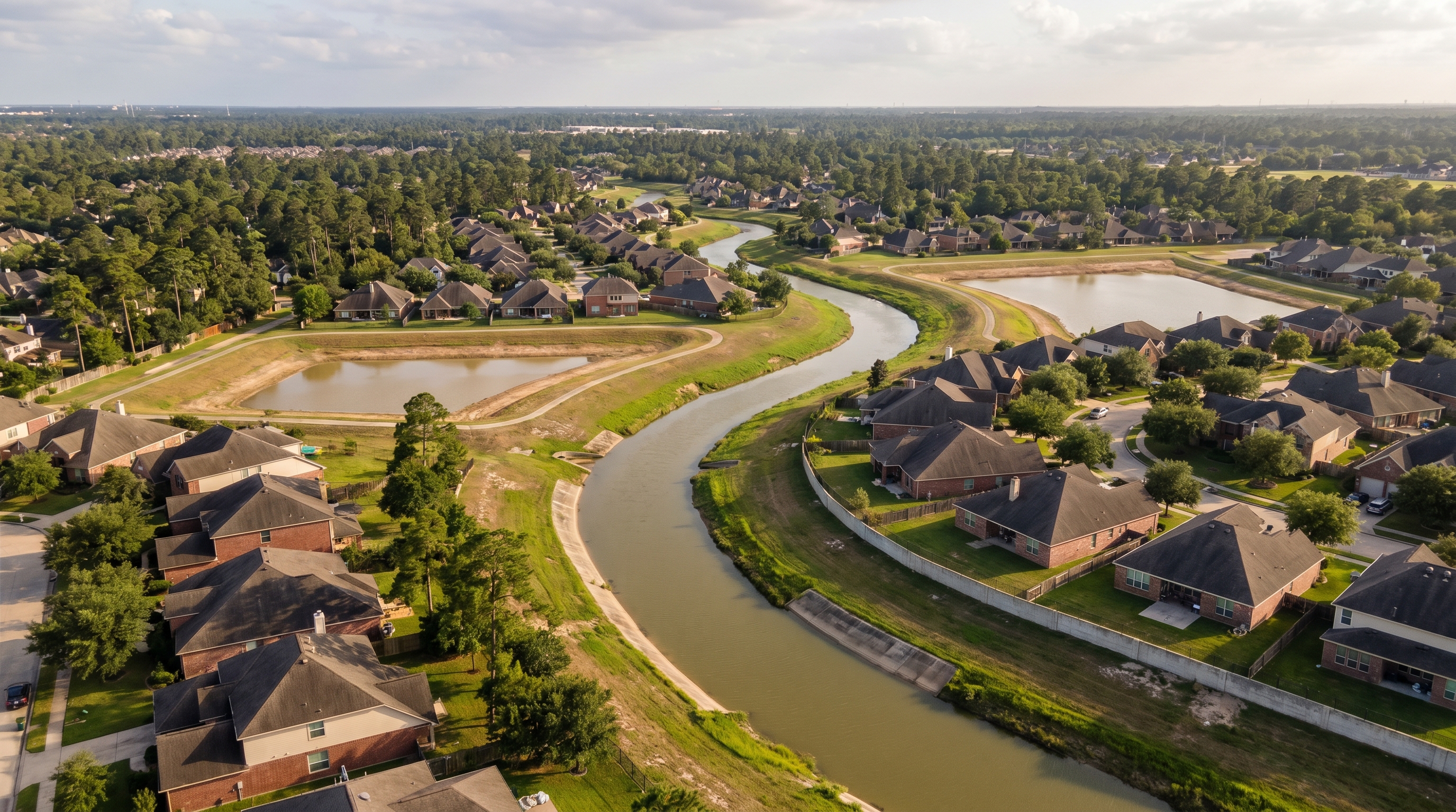
Understanding Houston's Bayou System and Your Property
Houston's drainage system is built around a network of bayous -- natural waterways that have been engineered into channels to carry stormwater. The four major bayous that affect residential property values are Buffalo Bayou, Brays Bayou, White Oak Bayou, and Cypress Creek.
Buffalo Bayou runs east-west through the center of Houston from the Barker Reservoir through Memorial, River Oaks, downtown, and the East End to the Houston Ship Channel. Properties within 500 feet of Buffalo Bayou's channel are most likely to fall within FEMA Zone AE. The Buffalo Bayou corridor includes some of Houston's most expensive real estate in River Oaks and Memorial, where flood risk and property values create a complex dynamic -- homeowners invest in elevation, flood barriers, and premium insurance to protect high-value properties.
Brays Bayou runs east-west through southwest Houston from Highway 6 through Meyerland, the Medical Center, and the University of Houston area. Brays Bayou has historically been Houston's most flood-prone corridor, with the Meyerland neighborhood experiencing repeated flooding in 2015, 2016, and 2017. The ongoing Project Brays channel improvements are designed to reduce that pattern significantly.
White Oak Bayou runs through northwest Houston and the Heights neighborhood. White Oak Bayou improvements have reduced flooding in the Heights area, though properties immediately adjacent to the channel remain in mapped flood zones.
Cypress Creek runs through the Spring, Champions, and Cypress areas of northwest Harris County. Cypress Creek flooding during the Tax Day Flood and Harvey affected thousands of homes in the Champions Forest and Raveneaux neighborhoods.
Frequently Asked Questions
What FEMA flood zone is my Houston property in?
You can look up FEMA flood zone designations for any Houston-area address for free at the FEMA Flood Map Service Center (msc.fema.gov) by entering the street address. The Harris County Flood Control District also provides an interactive flood map at harriscountyfcd.org with additional drainage and infrastructure data specific to Harris County. Both tools display the current effective Flood Insurance Rate Map for any Houston-area address.
How much does flood insurance cost in Houston?
Flood insurance costs in Houston depend on the FEMA flood zone classification and individual property characteristics under NFIP Risk Rating 2.0. Properties in Zone A (high-risk) typically pay $1,500 to $4,000 or more per year. Properties in Zone X (moderate or minimal risk) can obtain preferred-risk policies for approximately $400 to $800 per year. Private flood insurers may offer competitive alternatives, particularly for newer construction built to current elevation standards. (Sources: NFIP Risk Rating 2.0 rate tables, Texas Department of Insurance)
Did 80% of Harvey flooding really happen outside flood zones?
According to analysis by the Harris County Flood Control District and FEMA, approximately 80% of residential structures that flooded during Hurricane Harvey in 2017 were located outside mapped FEMA Special Flood Hazard Areas (100-year floodplain). Harvey's rainfall exceeded the 500-year storm threshold in multiple Houston watersheds, meaning areas classified as low or moderate risk experienced flooding that exceeded historical models. This is why I recommend flood insurance even in Zone X. (Sources: HCFCD post-Harvey analysis; FEMA Harvey damage assessment)
What has Houston done to reduce flooding since Hurricane Harvey?
Harris County voters approved a $2.5 billion flood infrastructure bond in August 2018 to fund more than 230 flood mitigation projects including channel widening, new detention basins, and property buyouts in high-risk areas. As of 2026, the Harris County Flood Control District has completed or has under construction the majority of these projects. Major improvements along Buffalo Bayou, Brays Bayou, White Oak Bayou, and Cypress Creek are designed to reduce the 100-year floodplain footprint for thousands of residential properties. (Source: HCFCD bond program status reports)
Should I buy flood insurance if my Houston property is in Zone X?
I always recommend it. During Hurricane Harvey, the majority of flooded homes were outside FEMA's high-risk zones. Preferred-risk flood insurance policies for Zone X properties cost approximately $400 to $800 per year and provide up to $250,000 in structure coverage and $100,000 in contents coverage through the NFIP. For a homeowner with a $350,000 home, that's roughly $1 to $2 per day for protection against a catastrophic loss. (Sources: NFIP preferred risk policy rates; HCFCD flood risk guidance)
Key Takeaways
- FEMA classifies Houston flood risk into Zone A (high risk, insurance mandatory), Zone X shaded (moderate risk, 500-year floodplain), and Zone X unshaded (minimal risk) -- each with different insurance requirements and cost implications.
- Flood insurance under NFIP Risk Rating 2.0 costs $1,500 to $4,000 per year in Zone A and $400 to $800 per year in Zone X for Houston-area properties.
- Hurricane Harvey in 2017 caused $125 billion in damage and flooded more than 150,000 Houston homes -- approximately 80% of which were outside mapped FEMA flood zones.
Questions to Ask Before You Buy
- Do you know the FEMA flood zone for every property you're considering?
- Have you checked the Harris County Flood Control map for nearby infrastructure projects that may reduce future risk?
- Have you gotten flood insurance quotes BEFORE making your offer -- not after?
Get Your Property-Specific Flood Analysis
Wondering how flood risk applies to the specific neighborhoods you're evaluating? Curious whether the Harris County bond improvements have changed the flood map for your target area? Want to know what sellers in flood-affected neighborhoods are required to disclose?
We provide a property-specific flood risk analysis for every listing we represent -- including FEMA zone status, historical flood events within the subdivision, proximity to bayou channels, and applicable insurance cost estimates. It's the same analysis we use for our own buying decisions.
Call or text: [PHONE NUMBER] | Visit: [WEBSITE URL]
Know someone looking at homes in Houston who has questions about flooding? We're never too busy for a referral.
Ready to Take the Next Step?
Our team specializes in Houston real estate.
Contact The Property Joes Group